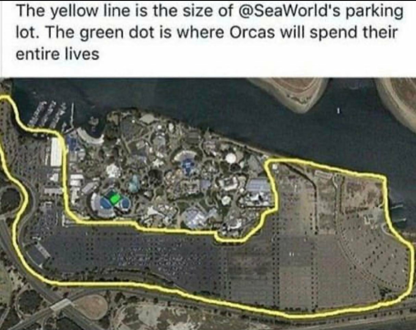
Cows Look Like Maps@sh.itjust.works to Fuck Cars@lemmy.worldEnglish · 2 years agoI feel sorry for the orcas.sh.itjust.worksexternal-linkmessage-square41linkfedilinkarrow-up1948arrow-down164
arrow-up1884arrow-down1external-linkI feel sorry for the orcas.sh.itjust.worksCows Look Like Maps@sh.itjust.works to Fuck Cars@lemmy.worldEnglish · 2 years agomessage-square41linkfedilink
minus-squarebassadlinkfedilinkEnglisharrow-up20arrow-down1·2 years agoI feel like this is the same for any animal species. Does someone has a map of world’s land use for human activities ? maybe this one ? https://www.nature.com/articles/s41597-022-01284-8/figures/2
minus-squareEphera@lemmy.mllinkfedilinkEnglisharrow-up10·2 years agoNot for the whole world, but someone recently posted this map of Germany here: Source: https://x.com/cvictordus/status/1791961219143766322 From top to bottom, left to right, the bigger areas say: Energiepflanzen → plants grown for generating electricity Vegetation → vegetation, just the random plants around the place presumably Pflanzliche Ernährung → plant-based food Viehfutter → forage, i.e. plants grown to feed animals (which will mostly be used for animal-based food). Siedlung + Industrie → industry and the places they build to house workers Wohnen → housing Verkehr → traffic (presumably parking + roads etc.) Rest → remaining, unclassified areas Wasser → water Wald → forest So, we do have some areas where animals can hang out, mainly forests, but as the map you linked points out, essentially none of it is wilderness either. The forests are commercially used and suffer from monospecies trees.
minus-squarehex@programming.devlinkfedilinkEnglisharrow-up6arrow-down2·2 years agoHoly shit. No wonder the ecosystem is going to shit. We’re so fucking greedy. The red spots look like an infection.

I feel like this is the same for any animal species. Does someone has a map of world’s land use for human activities ?
maybe this one ? https://www.nature.com/articles/s41597-022-01284-8/figures/2
Not for the whole world, but someone recently posted this map of Germany here:
From top to bottom, left to right, the bigger areas say:
So, we do have some areas where animals can hang out, mainly forests, but as the map you linked points out, essentially none of it is wilderness either. The forests are commercially used and suffer from monospecies trees.
Holy shit. No wonder the ecosystem is going to shit. We’re so fucking greedy. The red spots look like an infection.