In fact, you can speak Slovak in Czech Rep. and people will understand you, the same the other way around.
- 0 Posts
- 17 Comments

 2·7 months ago
As a Slovak, I am frustrated. The opposition seems unable to gain support from voters on the countryside, which is the majority of the population - they are the easiest to convince, usually by lying and fearmongering (i. e. “Korčok will send slovak men to Ukraine”), or giving promises they plan on never achieving but sound nice (reducing prices, even though they are doing the opposite).
The current government has plans to dissassemble the slovak TV and radio in favour of a state influenced alternative (essentially for propaganda purposes), is reducing punishment for criminals, rapists and thieves (as many of them are now in the government).
The country’s debt is growing (now at ~7b euros), railways, healthcare and schools are falling. Things still kind of work, but they are held by duct tape.

 14·8 months ago
That’s definitely not normal. The rendering can be a bit slow, but everything else shold be usable. Unless you have a low-range phone. If that is the case, I can recommend Organic Maps, which are much less resource-intensive.

 2·10 months ago
Organic Maps currently only supports metro/subway navigation, not buses, trains or other types of PT (although they are planning on introducing a new map layer for that). Bike routing works, although only fully separated bike paths are rendered.

 1·10 months ago
Hmm, maybe some forum platform would be a good alternative? I feel like the Reddit format of Lemmy focuses more on news, rather than the forum format which is more about deeper discussions… Just an idea.

 3·10 months ago
Have a look at the cyclosm.org map for details about the type of infrastructure, surfaces, bike parking, facilities and low-speed streets in your area. The map is using openstreetmap.org data, so feel free to add any missing infrastructure.

 3·11 months ago
Well, you can create an account from EU, although mine got locked after creating just one blog post. And the support does not seem to respond, so I moved to a different platform.

 3·11 months ago
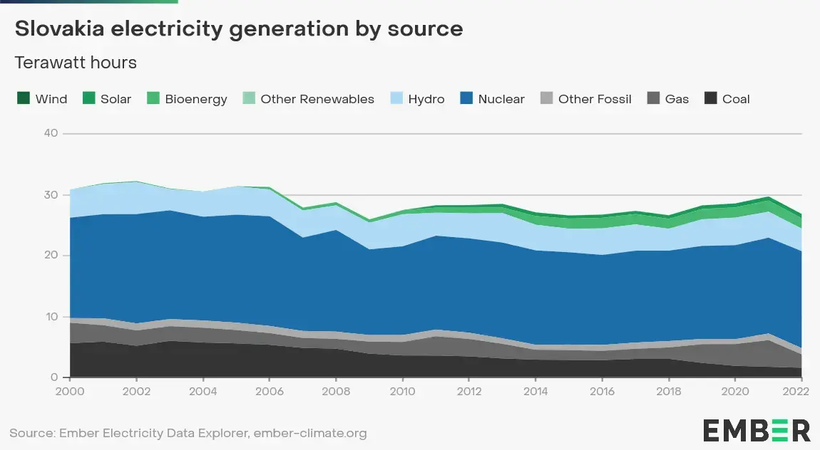
This is the energy mix for Slovakia (I live there :]) Nuclear and hydro are the most used sources.


 2·1 year ago
I usually map these with a bare node - you could also use crossing=unmarked. I honestly don’t think a new tag is necessary.

 4·1 year ago
Oh wow, big tech single-handedly curing my internet addiction! Love it!

 13·1 year ago
OnlyOffice has a usable client for mobile. And it’s FOSS.
I absolutely love CyclOSM. It’s great for bike commuting, as it differentiates between separated cycle paths and cycle lanes, shows one-way streets that allow opposite bicycle traffic, good/bad surface quality, 20 and 30 km/h streets and bike stands.

 3·1 year ago
OSM has much better coverage in Europe as more volunteers contibute. I heard it’s not that great in the US.

 3·1 year ago
I love your style of writing :) I’ll bookmark your site in my gemini browser. I also think the post fits as it’s urbanism- and community-related.

 4·1 year ago
I prefer to map them separately. For paths going along the road I use
highway=footway+footway=sidewalk, for separate paths justhighway=footway. You can also addsidewalk=separateto the road, so that routing software knows to prefer the separately mapped sidewalk to just using the road.

 1·1 year ago
Peertube is a good federated alternative to Youtube, it also connects to the Fediverse and there is a central search engine called Sepia Search, which makes it easier to find content on the different instances.

Slovak is pretty interesting in this aspect, you basically have this: á, ä, č, ď, é, í, ĺ, ľ, ň, ó, ô, ŕ, š, ť, ú, ý, ž