
True, “not killing each other” is a great basis for things.
Though when there’s an oppressor and those being oppressed, as a rule I’m going to side with the oppressed.


True, “not killing each other” is a great basis for things.
Though when there’s an oppressor and those being oppressed, as a rule I’m going to side with the oppressed.


It will give summaries of search results with links (fancy Google), but also those summaries will be inaccurate (it lies)


Oh, certainly. And the military has much better weapons (and training) than most 2A advocates.
My personal thoughts are that if even 5% of the population of large cities stood up and (even unarmed) said “no, you’re not going to destroy the country” that would have a significant impact.
(for residents in the DC metro area, that would be over 300,000 people, which you’ve exceeded in past protests - across the country if you could hit the 5% (17 million) protest target, you would certainly have a significant impact)
I know there’s a 50501 movement. I don’t know the size of it, (long way to go) but I think they’re still gaining momentum.
Long story short though, I really feel like this isn’t something that can be fixed by legislation or voting. That can help later, and can help support outside movements, but the people need to act, not just the politicians.


I believe the other user was trying to avoid explicitly stating that Americans need to use the powers given them by the second amendment to directly take back their country, without engaging in the existing (apparently ineffectual) political processes.
Apparently I’m avoiding saying it directly too, perhaps I don’t want to be directly encouraging anything.
Anyways, their intent seemed very obvious to me from their first comment (so I can see where their frustration came from), but I’m not educated enough in the US political system to be distracted by the details of 2/3rds majorities etc.


That SMART acronym is for internal computer drives, has been in use since about 1995, and is a wonderful thing - the drive keeps track of how many errors it encounters reading, how many bad sectors on the drive, how many hours it’s been powered on, and a whole bunch of other stats.
And then, you, the user (/sysadmin) can, while sitting at the computer, get a report of all these stats and notice if the drive is starting to fail so you can plan a replacement instead of it just dying unexpectedly.
Someone might have made an acronym for “smart” light bulbs, but it would be completely unrelated to the internal computer drive acronym.


(though it didn’t pay wall me for some reason 🤷)


So if I download an image from the web with GPS data, and then open it in an app that just reads images (so it doesn’t need location permissions)… That app (on some phones) gets a modified version of the file?
Which could make me think that the image doesn’t have location information.
Which could result in me uploading that file using a browser (that does have location permission turned on) to a website, and I think it’s safe to share because there’s no private information in the image, but my phone has conspired to mislead me.
Yes, that is cursed.


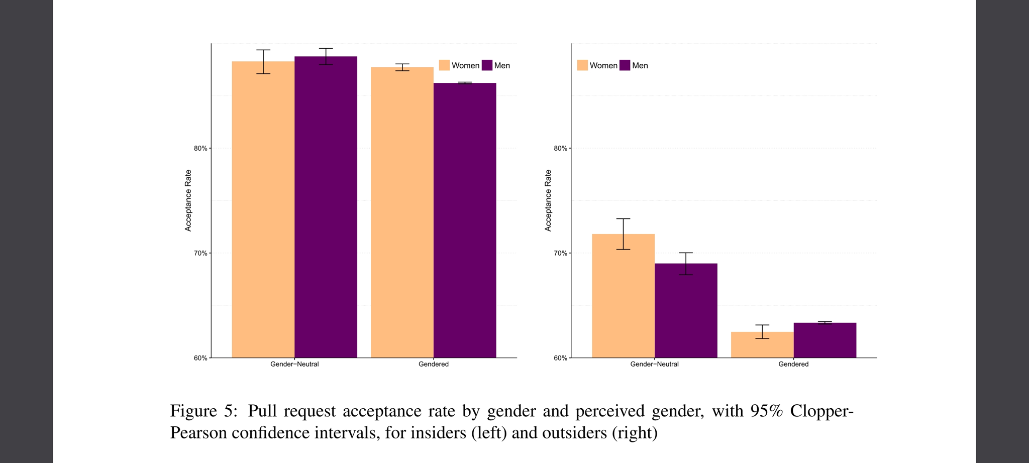
Page 15 of the pdf has this chart 
(note the vertical axis starts at 60% acceptance rate)


I really do appreciate the work you put into Beehaw, but to echo what others have said, I don’t think anyone wants this to be unsustainable for you, or anyone else working on Beehaw.
At the least I think it could be reported as part of donations/expenses? Rough numbers would be fine too (because the overhead of tracking hours is not fun). So I’m imagining something like:
400 hours unpaid work (2 full time people working, 1 part-time) (if paid, that’s $6,000 at minimum wage, $8,800 at a livable wage)
Which is a lot of money, and very scary, but at least it makes the behind-the-scenes work visible.
That said, I’m going to go set up a monthly donation now 🤗


From what I recall they were saving all the packets being broadcast as they drove past. (as opposed to only logging SSIDs)
Edit: Yup, it is as I had thought - but also it was more intentional than I had remembered: https://www.wired.com/2012/05/google-wifi-fcc-investigation/
(unpaywalled link) https://12ft.io/proxy?q=https%3A%2F%2Fwww.wired.com%2F2012%2F05%2Fgoogle-wifi-fcc-investigation%2F
And people brewing coffee on a keurig don’t think about the process of making coffee as much as someone who grinds their own beans and brews a pour-over.
The output of the two is different. And while they can serve the same function (providing caffeine in the form of a drink), if someone needs artisan coffee, the keurig will not do.
And if someone has only ever used a keurig, they may not know where to start.
Anyways, I contend that we need to do a better job actually interesting people in artisan essays, so the slop produced by LLMs is more easily identified as such.
Of course that requires a desire to educate people for a reason other than extracting economic value from them, so it’s unlikely to become widespread.